By: ishaana aiyanna
August 9 2023
Geolocation for fact-checking: Why the ‘where’ is important
Share Article:


(Source: Freepik.com)
Ever noticed how, during a big news event, a headline like, ‘Viral video of… watch here,’ pops up on your social media feed? More often than not, most viral videos and images are shared without context. They are either from a different time/different event or are falsely attributed to the news event or incident.
Civil unrest, natural disasters, and reports of attacks are all accompanied by such visuals. Persistent disinformation and conspiracy theorists also share such information to support theories like climate change denial, new world order, and QAnon.
Why asking ‘where’ is important
The consequences of such misattribution can create more unrest and fuel more misinformation, leading to escalation of violence and panic. We have seen such visuals during the French riots triggered by the shooting of a teenager by French Police, Manipur violence, Haryana violence, among others.
One example was a video clip that was shared showing a sniper shooting from a rooftop. It was shared to claim that it was from France and happened during the recent violence. But a simple reverse image search showed that the video was, in fact, a part of an older satirical video that was originally shared on Snapchat nearly a year ago.
Through geolocation we also found that the video was originally from Hautes Noues, Villiers-sur-Marne, a suburb to the east of Paris, while the rioting took place in Nanterre, a suburb to the northwest of Paris. Geolocation allows us to match landmarks, boards, and other features on a map with that in a photograph/video to identify the location and other relevant information to debunk a claim.
How to geolocate a video or an image?
Let's go through the process of geolocating this image of the Statue of Argentine Marxist revolutionary Che Guevara. For the sake of understanding, let’s say the claim states that the statue is in Kerala, a southern State in India with a Communist government.
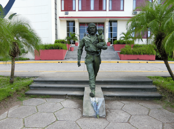
Statue of Argentine Marxist revolutionary Che Guevara.
Context: When you see an image on your feed or a video shared with you on social media, first look for the context. What is the accompanying text with which the image was shared? Was there a particular news event that the image or video is linked to?
In our case: The image was shared with the information that this statue was erected in the State of Kerala, India.
Look for clues: Once you’ve established the context, the next thing you need to look for in the image is clues. These can be distinct features in the background or foreground of the image, like mountains, waterbodies, buildings, or vegetation. 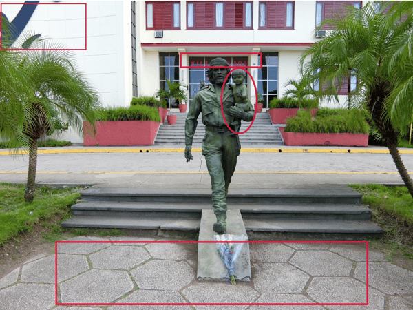
Distinct identifiers in the picture have been marked in red.
In this image, Che is holding a child in front of a building. In the left corner, we see some markings on the wall. On the door behind the statue, we see some text. The pavement tiles in front of the statue are hexagonal in shape.
Searching for similar or same images: With internet proliferation, it is highly likely that an image has been taken and posted on the internet before. A reverse image search using Google, Bing, or Yandex helps you find if the same or similar images have been shared elsewhere. If it is a video, you can take a screenshot and run a search on it. Alternatively, you can run a simple search using keywords.
We tried the latter (keywords ‘Che Guevara Statue in Kerala’), and the following results came up.
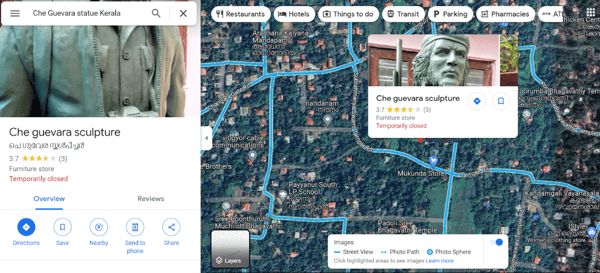
(Source: Google Maps)
Clearly, there are no similarities between the two statues.
The image on the left is the image we are trying to geolocate, and the image on the right shows the results that Google Maps showed. (Source: Altered by Logically Facts)
Since there are no other visible images of statues of Che Guevara on Google Maps in Kerala, we can either run a reverse image search or do a keyword search on Google Images describing the image.
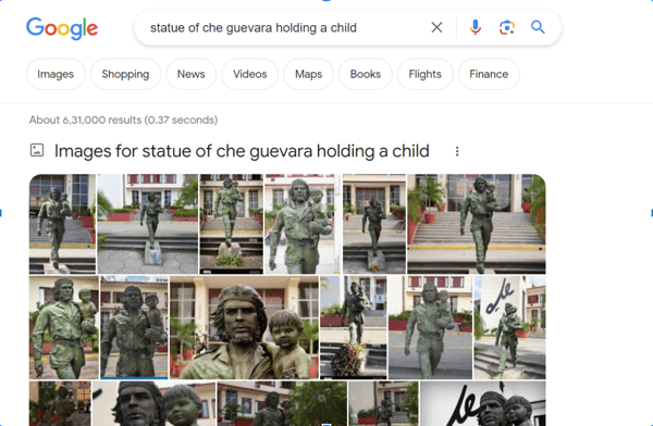
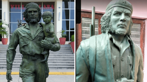
We have used ‘Statue of Che Guevara holding a child’ as the keywords. (Source: Google Search)
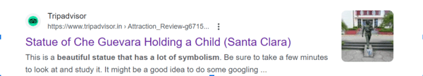
The pictures from the keywords search match our image; the statue is in front of a similar building and holding a child. The search result states that the statue is from Santa Clara, a City in Cuba.
Web search shows that the statue is in Cuba. (Source: Google Search)
Let’s map it: Satellite imagery is incredibly helpful in geolocation. 3D terrain filters in maps show water bodies, roads, vegetation, and buildings. Most tools like Google Earth also let you access historical data, which is especially useful if looking at a landscape before or after an event like a bomb blast, protests, or fire. Using the Street View feature on Google Maps, we can also access panoramic images and 360-degree images uploaded by users.
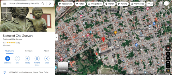
A satellite view of where the statue is in Cuba. (Source: Google Maps)
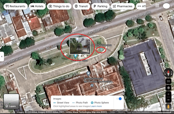
Using Street View, we can see a 360-degree image very similar to our original image, where we can see similar vegetation and markings on the building as in our original image.
(Source: Google Maps)
The image provided by a Google user via Street View shows similar vegetation and markings on the building as in our original image.
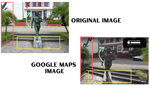
Comparison between the original image and the image found on Google Maps. (Source: Altered by Logically Facts)
A closer look at the image shared by the Google user helps us verify that it is indeed the same Statue in the City of Santa Claria, in front of the Sede provincial del Partido Comunista de Cuba or the Provincial Headquarters of the Communist Party in Cuba.
Limitations of geolocation
While geolocation is easily accessible, some limitations are that it is time-consuming and it involves a lot of trial and error. Sometimes images are too blurred with no distinguishing details, which makes it difficult to geolocate.
Here is a list of free tools to help you with geolocation
- Google Maps - Available on your phones, it is the easiest way to search for an image or location.
- Mapillary - a street-level imagery platform that scales and automates mapping using publicly available photos of places across the world.
- Peak Visor - 3D maps and peak identifier, useful for images with mountains and hilly terrains in the background.
- SunCalc- Useful to determine the time of the day when an image was captured.