By: Rajini KG
February 3 2023
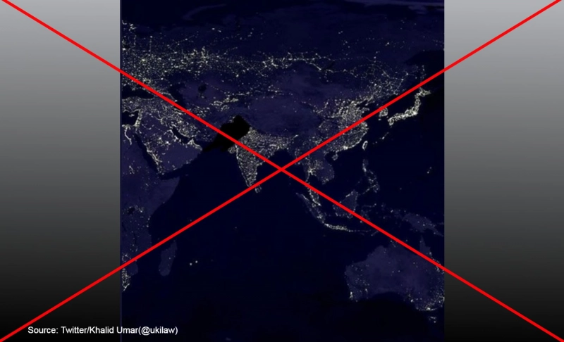
False: A satellite image shows a power outage in Pakistan on January 23, 2023.
Share Article:


Fact-Check
The Verdict False
A 2000 image by NASA's Goddard Space Flight Center has been digitally altered and linked to the current economic crisis in Pakistan.
Claim ID 867f4c85
Context
Pakistan faced a power outage on Monday, January 23, 2023, due to a voltage fluctuation in the national grid, affecting major cities like Islamabad, Karachi, and Rawalpindi. The power was only restored on Tuesday, January 24. Pakistani Prime Minister Shehbaz Sharif has ordered an investigation into the outage. The country is currently facing an economic crisis caused by rising debt, higher energy import prices, declining foreign exchange reserves, global inflation, political unrest, and a persistent decline in GDP growth.
Images and videos claiming to show a nationwide power outage in Pakistan went viral on social media. One such image, showing nations around the world lit up with a dark patch over Pakistan, was posted on Twitter with the caption, "That darkness next to India is Pakistan. People who want #GilgitBaltistan to be part of Pakistan should be ashamed of themselves and apologize (sic)."
However, this claim is false. A satellite image created in 2000 using Operational Linescan System (OLS) data under the Defense Meteorological Satellite Program (DMSP) by NASA's Goddard Space Flight Center has been digitally altered to make it appear as though it was captured during the recent power outage in Pakistan.
In Fact
A close look at the image indicated that the photograph had been digitally altered. One indication was that the area in black, supposed to denote Pakistan's power outage, also contains some parts of India.
A reverse image search revealed that the image is from the year 2000. NASA's Jet Propulsion Laboratory posted the original image on November 9, 2000. The image was titled "Global City Lights," and the description reads, "The Eastern U.S., Europe, and Japan are brightly lit by their cities, while the interiors of Africa, Asia, Australia, and South America remain (for now) dark and lightly populated. (Image by Craig Mayhew and Robert Simmon, NASA GSFC. Based on data from the Defense Meteorological Satellite Program)."
According to NASA's Earth Observatory, the image was created by Marc Imhoff, a biologist at NASA's Goddard Space Flight Center, and a team of six researchers. The light patterns in the image match the image linked to Pakistan's power outage. The original image has been cropped and circulated with a misleading narrative.
NASA's Earth Observatory also posted the original image on its website on October 19, 2000. It states that using satellite images of the light that cities produce at night, Imhoff and a group of researchers developed a method for mapping urbanization on a national scale.
Both the Smithsonian National Air and Space Museum and National Science Foundation also posted the picture of the city lights on their websites. Therefore, it confirms that the image was taken in 2000 to map urbanization and is unrelated to Pakistan's economic crisis.
The Verdict
An old image of the Global City Light project by NASA's Goddard Space Flight Center was digitally altered and falsely linked to a power breakdown in Pakistan on January 23. Therefore, we have marked this claim as false.
